From Route Map to Stop Sign: The Layers of a Transit Journey
Learn how route maps, schedules, stop markers, and vehicle displays work together so you can choose a connection and board the right transit service.
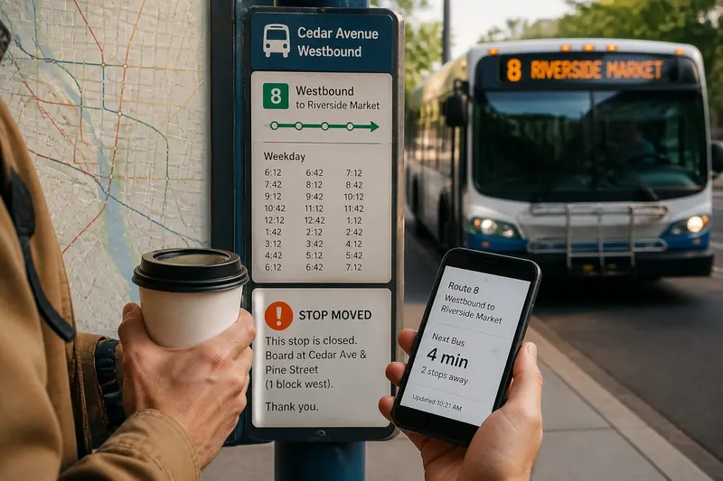
You are standing beside a bus shelter with a coffee cup in one hand and your phone in the other. A route map can show which line approaches your destination, but it cannot identify the exact boarding marker or confirm that the bus pulling up is yours. Each transit sign has a narrower job.
For a transit journey, separate the questions: which service connects the places, when it runs, where it boards, and which arriving vehicle to take. Knowing which source answers each question makes a confusing interchange more manageable.
Choose a route with the transit map
A route map shows relationships across the network: lines, stations, stops, branches, and connections. It helps you choose a service, but its geography may be simplified. A line drawn through a street does not necessarily show the exact side of the street or the precise boarding point.
Start with the transit agency’s map or journey planner. Note the route name or number, the direction of travel, any transfer, and the destination stop. Then check the agency’s schedule or service information for the day and time you plan to travel. The map explains where a service goes; the schedule describes when it is planned to run.
For current disruptions, check the agency’s service alerts or live arrival information as well. A map may still show a stop or connection that a temporary closure has changed.
Check direction, not just the route number
A route number identifies a service, but often not which way it is traveling. Opposing buses may carry the same number, while rail lines may have branches or separate platforms. The direction label may use a terminal, neighborhood, or major destination instead of the name on your trip plan.
Compare your planned direction with the label at the stop and on the arriving vehicle. If the names differ, check whether they refer to the same direction or whether the service has changed. Treat a matching route number as one clue, not the whole answer.
At a transfer, the map shows that services connect; station signs show how to move between them. Read transfer instructions before arrival if the interchange is unfamiliar, then follow the signs on site. Nearby platforms are not necessarily interchangeable.
Use the stop marker to find where to board
A stop marker identifies a boarding location. It may be a pole, shelter panel, platform sign, or curbside marker. At a large interchange, several markers can sit close together while serving different routes or directions.
Match the route listing and direction on the marker to your trip plan. A stop name or identifier can also help you check arrivals in an app or contact the agency. A posted timetable describes scheduled departures, but temporary changes may be announced separately.
Say you are taking an invented weekday trip from a library to a market, and your plan names the westbound 8 at Cedar Avenue. You find markers on both sides of the avenue. You check the direction labels and route listings, then wait at the westbound marker; the observable result is that the sign agrees with your planned direction, rather than merely showing the same route number.
What should each transit sign tell you?
Does a route map show the exact boarding point?
Usually, a route map shows the network and approximate stop locations, not the precise place to wait. Use the marker, platform signs, or station directions to locate the boarding area.
Does a route number tell you which way the vehicle is going?
No. Check the direction or destination label as well, particularly where the same route serves stops on both sides of a street.
How should you handle different arrival information?
A printed timetable describes scheduled service; a live display may give an updated estimate. If they disagree, check the display’s timestamp and the agency’s current service alerts before deciding whether to wait or adjust your plan.
What should you do if a stop is closed or relocated?
Look for a temporary notice and check the agency’s current alert or map for the replacement location. Follow the posted directions instead of waiting at the usual marker.
Confirm the arriving vehicle before boarding
Compare the vehicle’s route number and destination display with your notes. Do not rely on its color, shape, or the fact that other passengers are boarding. Similar vehicles can serve different routes, and a bus may display a branch or short-turn destination rather than the familiar endpoint.
If the display is difficult to read, check the route information on the vehicle’s side or ask the operator before boarding. If its destination does not match your direction, wait for a service that does. A brief check at the curb is less complicated than correcting the trip later.
Use a short check when the signs disagree
Imagine an invented trip to a civic center. Your plan says to take route 12 eastbound from Maple Street, but the stop marker lists route 12 without a direction and a nearby temporary notice says the stop has moved. You check the agency alert, which names a replacement stop on the next block; there, the marker lists route 12 eastbound. You then compare the arriving vehicle’s destination with the civic center direction before boarding. The result is a clear boarding decision; if the alert had not identified a replacement location, the sensible next action would be to ask transit staff or use the agency’s contact channel rather than guess.
- Check whether the route map connects your starting area and destination; if it does, note the service and direction, and if it does not, choose another route or transfer.
- Check the schedule for the planned day and time; if service is listed, use it to frame your departure, and if it is not, consult current agency information for another service.
- Check the stop marker’s route and direction; if both match your plan, wait there, and if either differs, inspect nearby markers or confirm the correct stop.
- Check for a closure or relocation notice; if one is posted, follow its replacement directions, and if none is visible but the stop appears unusable, check the agency alert.
- Check the vehicle display for both route and destination; if they match your plan, board, and if the destination differs, wait or ask the operator.
- Check whether a live arrival display is current; if its timestamp and service information are current, use it alongside the schedule, and if the information conflicts, consult the agency alert before changing plans.
Keep only the details needed for the trip
Save the route, direction, transfer point, and destination stop you actually need. If information conflicts, identify the unanswered question: a delayed arrival differs from a closed stop, and neither is the same as a route that does not reach your destination. Report a specific problem through the transit agency’s usual contact channel, including the route, stop, and direction where relevant.
Transit journey planning is easier when a route map selects the connection, a schedule frames its timing, a stop marker locates boarding, and the vehicle display confirms the ride. Before stepping aboard, give the destination display one last look; it is a small courtesy to your future self.